
LETTER | Preparing for more severe weather
LETTER | Naturally, tropical rainforest climates like Malaysia are prone to flood. Pristine virgin forest delays the flow of rainwater using the natural peat soil as a sponge.
Natural mitigations like lakes, ponds, wetlands and freshwater swamps will play a vital role as well. Human civilisation develops closer to water sources and gets exposed to flooding risk.
However, under the name of development, the natural flood mitigations are removed and replaced with smaller retention ponds and in some cases with flood mitigation projects. Unfortunately, plantation and agriculture activities that cover large swathes of land are not subjected to such requirements.
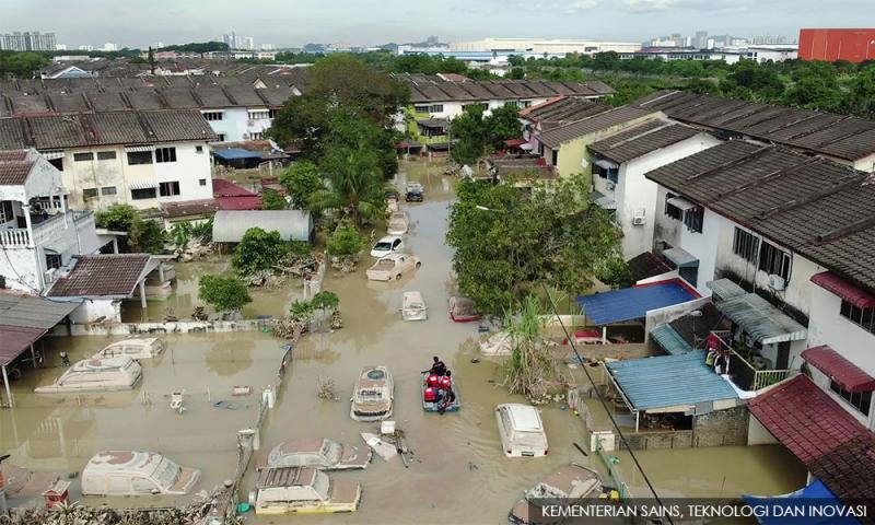
The recent flood that hit the west coast of Peninsular Malaysia caused severe damages and loss of life. When it precipitates continuously for more than 12 hours in large areas, authorities should have been on alert.
Continuous rainfall will saturate the soil and increases surface runoff drastically. This causes more water collected within a river basin. Mind you that all drainages are eventually connected to rivers and this increase of water volume will have to be dumped into the sea.
In densely populated areas, lesser permeable surfaces also increase surface water flow almost immediately when it rains.
Areas that are valleys and closer to main river connections become high-risk areas. Many floods, as well as drought modelling, have been carried out and situation such as now is predictable.
On top of the annual monsoon, there are other seasonal weather patterns that come once in 50 years, 100 years, etc, and the well known El Nino and La Nina conditions. We are also facing an unknown risk parameter from climate change that is affecting the whole world.
There are warnings of heavy rainfall in a few more days. Limited sunshine will keep the soil quite saturated and any heavy downpour will pose a flooding risk.
What are the immediate actions that the government need to take?
- Previous flood simulation reports and real-time data by the Irrigations and Drainage Department (DID) and other relevant agencies must be used to identify high-risk areas on top of current affected areas. Using this information, the state governments, local authorities and emergency services must be put on standby. Potential high-risk areas are closer to rivers, low land, flat land and areas that have frequent or severe flooding problems.
- Downstream areas that have dams and major flood pumping stations (including the Smart Tunnel) might also be affected due to the release of water and pumping. Precaution and proper warning mechanisms must be put in place to avoid unwanted incidents.
- Watergates and other mitigating facilities must be kept at optimum operating conditions. A situation like Taman Sri Muda in Shah Alam should not reoccur and hamper recovery.
- The slope monitoring is under the Works Ministry (KKR). Many years ago, KKR has developed visual detection of a failing slope and produce communication materials for simple ways to identify potential slope failures. KKR should use MySejahtera and other social media platforms to share this information to alert members of the public to take precautions and assist in reporting to the authorities for quick action that can save lives and ensure roads are operational during emergency situations.
- The government must also utilise telecommunication or handphone signals to identify trapped victims if such incidents reoccur and this must be done quickly before the phones or devices run out of battery. The government must rope in telco companies to assist the authorities. Similarly, can MCMC use spotted SMS alerts to high-risk zones through telco companies? When high-risk zones are identified and clustered under certain codes, warning SMS or messages can be sent via signal zoning based on telco companies towers in the identified zones. This will allow anyone within that vicinity to receive warning messages and contact details for guidance.
Long-term solutions
The erratic weather pattern has been on the rise in the past decade and it is happening throughout the world. AWER would like to outline a few long-term solutions to mitigate the flooding risks.
- DID must be given enforcement power to ensure all recommended drainage and mitigation measures are fully complied with by developers and local authorities. DID must be allowed to issue work stop order if any non-compliance occurs.
- Mitigation projects are developed based on a particular locations existing condition. If land use of the area changes over time, the mitigation project is set to fail. This is mainly due to a possible increase in surface runoff beyond the design capacity of a flood mitigation project. Thus, a holistic flood impact assessment must be done to simulate the overall impact of every new development project within a local authority’s jurisdiction. This must also be vested as part of enforcement power to DID.
- Deforestation and loss of natural buffers for flood mitigation is also another factor that causes the flood situations to get more severe every year. While annual lip service is uttered on the protection of natural capital, it is unfortunate that it does not materialise. Thus, the auditor-general must investigate the rate of deforestation in the past 30 years and the actual virgin forest reserve that is left. This report must be presented to the Parliament in the next year’s sitting.
- The budget for flood mitigation and relevant infrastructure for 2021 and 2022 is approximately RM1.6 billion. It is vital to ensure that these allocations and future allocations do not go to waste. Similarly, the auditor-general must audit flood mitigation and flood-related infrastructure allocation and expenditure for the past 30 years. Projects must be categorised based on their success in mitigating flood occurrence. If there are projects that failed or upgraded due to previous failures, the reasons for such failures must be clearly identified. This is to map the potential risk a flood mitigation project faces in its operation cycle and make sure taxpayers’ money are put to proper use. This report must also be presented to the Parliament in the next year’s sitting.
- Predicting future floods to ensure proper mitigation actions is a must. The government must form a task force to simulate past erratic weather and current flood situation. This simulation is to predict changes in the weather patterns and to identify if there is any impact from climate change and the degree of interference. This task force must also identify if there is a predictable pattern of change. If there is a clear pattern it will assist to estimate mitigation project design with a recommended safety factor. In case there is no direct pattern, it will lead to high-cost mitigation measures as well as resettlement of high-risk zones to new locations. This task force must comprise capable experts and representatives from federal and state governments.
- Optimisation of telecommunication and digital platform for warning and communication to affected zones. The recent floods have shown the weakness of communication from authorities to the members of the public. Fortunately, the communication between the members of the public superseded government arms and arrive at faster and effectively rendered assistance. Thus, the government agencies at the federal, state and local government levels must streamline their communications to ensure seamless operation when a disaster such as a flood strikes our nation.
- Safety and stability of infrastructures such as buildings, bridges, flyovers, roads, etc must be carried out periodically in flood-hit areas. A strong current of floodwater can cause irreparable and irreversible damage that can cause further catastrophe.
Changing weather with climate change may become more extreme and hit us more frequently.
The earth is adjusting and the adjustment process needs us to adjust or we will perish in the process.
Let us be guided with science and data to chart a better future.
The writer is the Association of Water and Energy Research Malaysia (AWER) president.
The views expressed here are those of the author/contributor and do not necessarily represent the views of Malaysiakini.
RM12.50 / month
- Unlimited access to award-winning journalism
- Comment and share your opinions on all our articles
- Gift interesting stories to your friends
- Tax deductable